
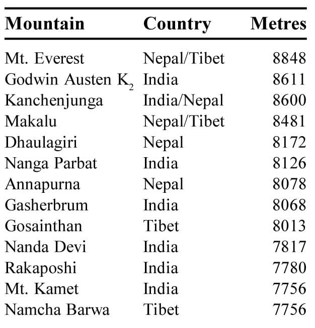
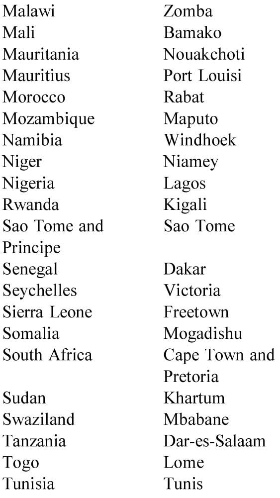
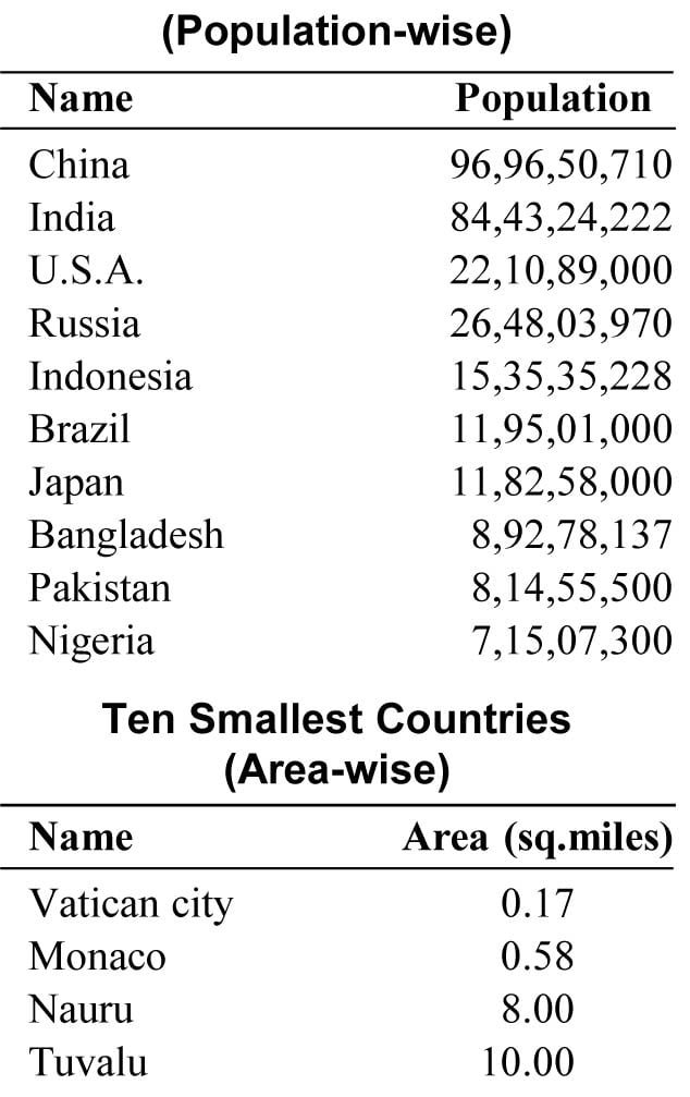
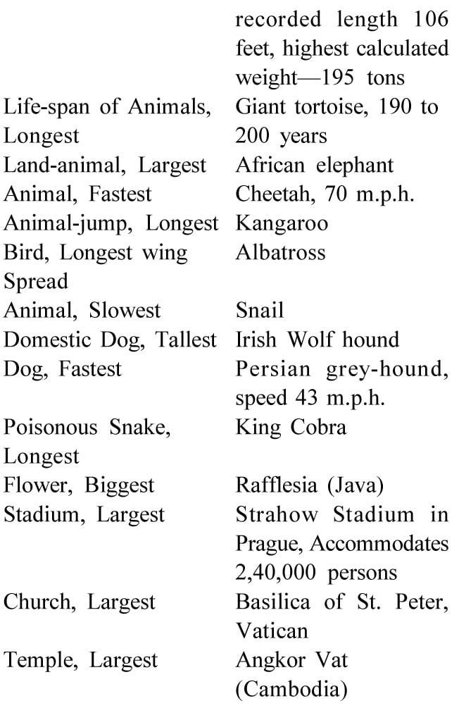
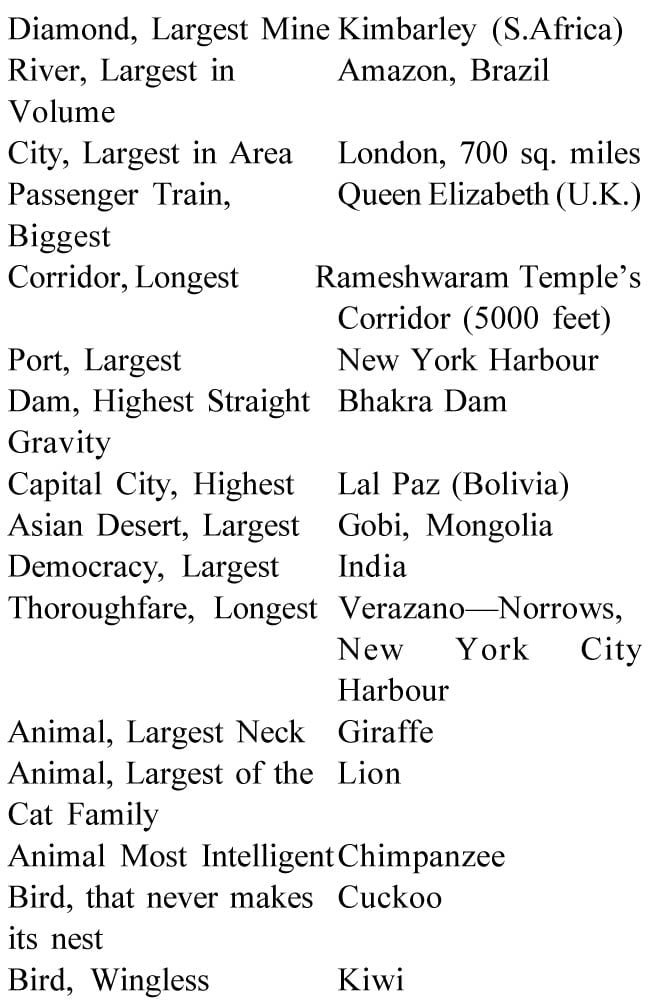
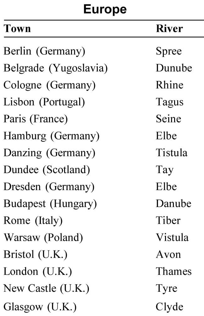
Highest Mountains


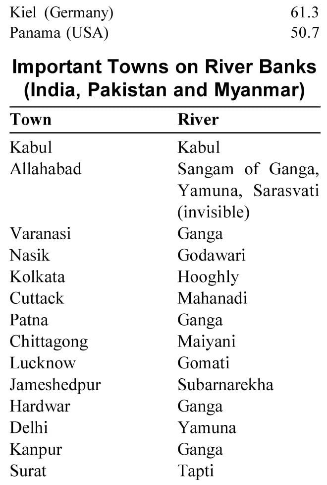
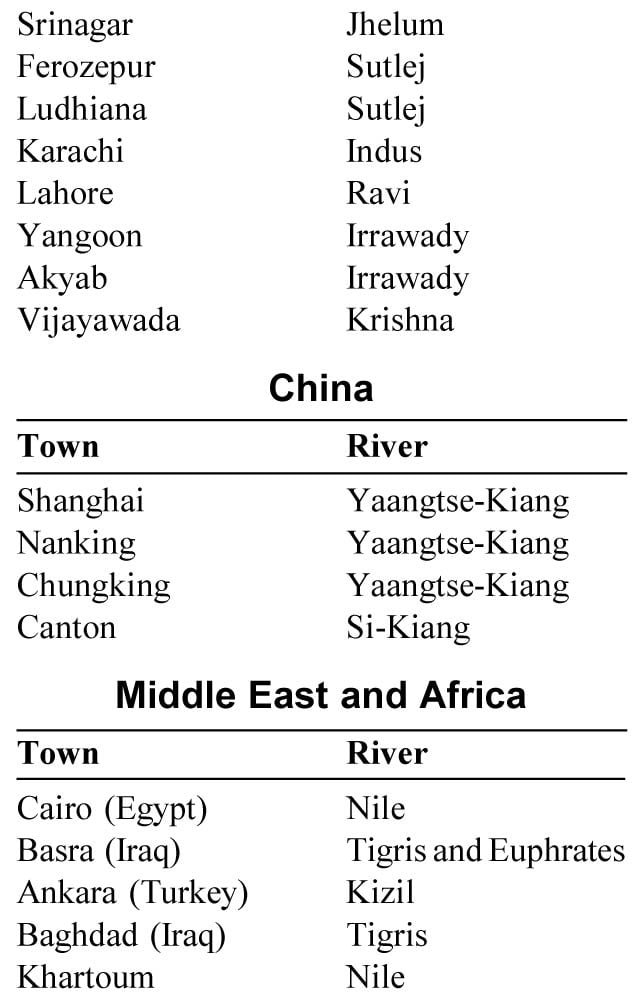


Some more Information (India)
Important National Highways
· N.H. 1 : Delhi-Ambala-Amritsar-Indo-Pak Border (546 km)
· N.H. 2 : Delhi-Agra-Kanpur-Varanasi-Kolkata (1490 km)
· N.H. 3 : Agra-Gwalior-Indore-Nasik-Mumbai (1161 km)
· N.H. 4 : Junction with N.H. 3 near Thane-Belgaum-Bangalore- Ranipet-Chennai (1235 km)
· N.H. 7 : Varanasi-Jabalpur-Nagpur-Hyderabad-Bangalore-Madurai-Kanniya-kumari (2369 km)
· N.H. 8 : Delhi-Jaipur-Udaipur-Ahmedabad-Mumbai (1428 km)
· N.H. 9 : Pune-Solapur-Hyderabad-Vijayawada (791 km)
· N.H. 15 : Pathankot-Bathinda-Ganganagar-Bikaner-Jaisalmer-Kandla (1526 km)
· N.H. 22 : Ambala-Kalka-Shimla-Rampur-Indo-Tibet Border near Shipki La (459 Km)
· N.H. 24 : Delhi-Bareilly-Lucknow (438 km)
· N.H. 39 : Numaligarh-Imphal-Palel-Indo-Myanmar Border (436km)
· N.H. 44 : Shillong-Passi Badarpur-Agartala (495 km)
· N.H. 47 : Salem-Coimbatore-Thrissur-Ernakulam-Thiru-vananthapuram-Kanniyakumari (640 km)
· N.H. 48 : Bangalore-Hassan-Mangalore (328 km)
· N.H. 49 : Kochi-Madurai-Dhanushkodi (440 km)
· N.H. 55 : Siliguri-Darjiling (77 km)
Total length of National Highways is about 35 thousand kilometres.
Some Long Distance
Trains in India
1. Kanniyakumari Express :
Mumbai to Kanniyakumari
Distance — 2150 km.
2. Minar Express :
Mumbai to Scunderabad
Distance — 800 km.
3. Pushpak Express :
Mumbai to Lucknow
Distance — 1420 km.
4. Netravati Express :
Mumbai to Kochi
Distance — 1850 km.
5. Ratnagiri Express :
Mumbai To Varanasi
Distance — 1510 km.
6. Paschim Express :
Mumbai to Amritsar
Distance — 1830 km
7. Tinsukia Mail :
Delhi to Guwahati
Distance — 1780 km
8. Himgiri Express :
Jammu Tawi to Haora
Distance — 1570 km.
9. Himsagar Express :
Jammu Tawi to Kanniyakumari
Distance — 3750 km.
10. Sarvodaya Express :
Jammu Tawi to Ahmedabad
Distance — 1680 km.
11. Gitanjali Express :
Haora to Mumbai
Distance — 1970 km.
12. Coromandel Express :
Haora to Chennai
Distance — 1660 km.
13. A.P. Express :
New Delhi to Secunderabad
Distance — 1670 km.
14. Karnataka Express :
New Delhi to Bangalore
Distance — 2440 km.
15. Kerala Express :
New Delhi to Thiruvanantha-
puram
Distance — 3060 km.
16. Vivekanand Express :
Guwahati to Thiruvananthapuram
Distance — 3570 km.
17. Tamil Nadu Express :
New Delhi to Chennai
Distance — 2190 km.
18. Magadh Express :
Patna to Delhi
Distance — 990 km.
19. Malwa Express :
Jammu Tawi to Indore
Distance — 990 km.
20. Konark Express :
Bhubaneshwar to Secunderabad
Distance—1150 km.


Geographical Instruments
Acrometer : Instrument used to measure weight and density of gases.
Altimeter : An instrument used to measure the altitude of an aircraft.
Anemograph : An instrument used to record pressure and velocity of wind.
Anemometer : An instrument used to measure the velocity of wind.
Aneroid barometer : It is used to measure atmospheric pressure.
Astrolabe : It is used to determine the position and altitude of celestial bodies.
Barometer : It is used to measure the atmospheric pressure.
Chronograph : A device used to record time.
Chronometer : An instrument used to measure time in the ship.
Compass : A device used to identify the direction on the basis of earth’s magnetic field.
Mariner compass : A magnetic compass used to determine the direction on a ship.
Gomiometer : An instrument used to measure the angles between crystal faces.
Hygrometer : An instrument used to measure the humidity of air.
Manometer : An instrument used to measure the pressure of a gas.
Pachy meter : Instrument used to measure small thickness.
Pyreheliometer : This instrument is used to measure the intensity of solar radiation.
Rain gauge : An instrument used to measure rainfall.
Scisomograph : Instrument used to measure the magnitude of an earthquake.
Thermocouple : Used to measure the changes in temperature.